Skip to main content Skip to footer

Virtual Spelunkers Guide to Warsaw Caves

Caving and Spelunking

About Warsaw Caves

Warsaw Caves Conservation Area takes its name from a series of seven caves found in the park. This guide will provide you with some information about the geologic history of the site and tips for exploring the caves and other natural features nearby.

For the best experience, bring along a headlamp or flashlight and be sure to wear sturdy shoes – no ropes or climbing gear required!

NOTE: For those who may be uncomfortable in an enclosed space, you may want to begin your explorations with Cave 5. It is easily accessible and is the most open and spacious of the caves. To find Cave 5, stand on the flat trail roughly 6m before the entrance of Cave 4, turn sharply to the right and make your way up the slope to Cave 5

How were the Warsaw Caves formed?

The Warsaw area is characterized by limestone bedrock formed in the Paleozoic-era seas that covered the entire region over 350 million years ago. This bedrock was shaped through a series of Pleistocene epoch glaciations, including the Wisconsin ice age which ended 10,000 years ago.

20,000 years ago, at the height of this ice age much of Ontario was covered in sheets of ice two to three kilometers thick. 12,000 years ago, when these glaciers began to retreat, meltwaters created prehistoric Lake Algonquin (present-day upper Great Lakes and Lake Simcoe) and Lake Iroquois (present day Lake Ontario).

The flow of glacial meltwater from Lake Algonquin to Lake Iroquois formed the Kirkfield Spillway, which included the Indian and Otonabee Rivers. These ancient rivers were very different from the shallow, placid Indian River we see today, being more like the modern-day Niagara River. The deep, swift, glacier-fed river shaped the landscape found within Warsaw Caves Conservation Area, leaving behind caves, kettles, limestone cliffs and ledges, underground channels, and other interesting natural features.

The caves were created by the chemical erosion of the limestone bedrock. Limestone has a distinctive crystal structure and it will fracture and crack in a specific pattern. As the ancient river flowed over the bedrock it made its way into and through these cracks. High carbon dioxide levels made the river water slightly acidic and it dissolved the limestone over thousands of years, widening the natural cracks and fissures in the rock. In time the river was flowing both over and through the bedrock, in its surface bed and in underground channels. This type of landscape is known as karst topography.

As the glaciers retreated, the weight of ice carried by the bedrock lessened and it rose up in a process known as isostatic rebound. The shifting of the bedrock and continued erosion caused the collapse of underground river channels, leaving behind a series of caves and the broken limestone landscape we see now.

The site is geologically stable today and the rebound of the bedrock means there is no longer water flowing through the caves, although there are still many underground rivers flowing through the area.

Cave 1

You can easily enter Cave 1 by either of two large openings. From the first chamber you make a descent of roughly 4.5m by way of several ledges. To the right is a passage that ends at a large chamber. To the left is a narrower passage that will lead you to cave 2.


Cave 2

The entrance to the Cave 2 is a bit of a squeeze, but it opens up into a chamber from where you can move in any one of three directions. Straight ahead across the flat polished rock is the passage that leads to Cave 1. If you look up, you will see fossils on the ceiling. To the left of the flat polished rock is a descent that dead ends at a series of lower chambers. If you move to the left, but bypass the descent, you will find a passage leading to Cave 3.


Cave 3

You have to enter Cave 3 feet first – find your footing on the right as you lower yourself through the cave entrance. Once you are in, you again have a choice of three directions of travel. To the right, beyond a mound of rocks is the passage to Cave 2. To the left is a horizontal crevice that you can crawl through to reach a circular chamber. If you climb up past the right-hand side of the crevice you will come to a pair of exits to the surface.


Cave 4

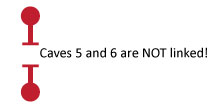
You will have to wiggle your way into Cave 4 feet first, but it is – quite literally – the coolest of the caves! This is the ice cave where the temperature is always about 2ºC and where you can find ice well into the summer season. To the left you can crawl your way into a small chamber or, to the right, through a narrow, hard-to-see passage that leads to Cave 5.


Cave 5

NOTE: For those who may be uncomfortable in an enclosed space, you may want to begin your explorations with Cave 5. It is easily accessible and is the most open and spacious of the caves. To find Cave 5, stand on the flat trail roughly 6m before the entrance of Cave 4, turn sharply to the right and make your way up the slope to Cave 5.

From the entrance of Cave 5 you can go left – feet-first to secure your footing – to enter a narrow passage that leads back to Cave 4. To the right you can follow a short open passage that offers several vertical climbs to the surface.


Cave 6

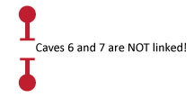
Cave 6 resembles a long corridor with high ceilings. The entrance is very steep, so be careful when lowering yourself in. If you feel uncomfortable entering here, there is another unmarked entrance 15m further down the trail. From the entry marker, moving to the left will lead you to a dead end, while moving to the right will take you down a passage that has several vertical exits.


Cave 7

To find Cave 7, carefully make your way across large slabs of broken limestone and descend through a crevice to the entrance. The cave itself is open to the sky. After making your way into the cave you will travel a short distance to an open area. You can exit here or continue on to another open area from where you have the choice of exiting or making a 10m underground belly crawl to the next exit.

After leaving Cave 7, you can make your way down to the path at the bottom of the slope. Then, return up the trail to the left to the parking lot OR follow the trail to the right to the Damselfly Pond.

Damselfly Pond

At the end of the Caves Trail, after visiting Cave 7, follow the trail to the right to continue on to Damselfly Pond. The Indian River begins to re-emerge here after flowing underground for several hundred metres. In the summer, if you sit quietly you can hear large numbers of black-winged damselfly wings beating! Stay very still and one may land on you!

Flatrock Beach

If you continue down the path, past the Damselfly Pond, you will arrive at Flatrock Beach. This is a serene place to stop for a snack along the shoreline or to drop in a fishing line.

Flatrock Beach is the final stop on trail. To return to the parking lot, you will need to retrace the trail back the way you came.

Contact Us

289 Caves Road
Warsaw, ON K0L 3A0
Township of Douro-Dummer

Latitude 44.461904
Longitude -78.131332

Email: 
warsawcaves@
otonabeeconservation.com

April to October
Gatehouse Local: 705-652-3161

October to April (Off-season)
Administrative Office:
705-745-5791

Gatehouse Hours

Operating Season:
May 10 - October 14, 2024

Check-in: 2:00 pm
Check-out: 12:00 pm

Sunday to Thursday 9:00 am - 4:30 pm
Friday and Saturday 9:00 am - 9:00 pm
Sundays of long weekends 9:00 am - 9:00 pm

Map

Subscribe to our News

Stay up to date on Otonabee Conservation's activities, events, programs and operations by subscribing to our News.

This website uses cookies to enhance usability and provide you with a more personal experience. By using this website, you agree to our use of cookies as explained in our Privacy Policy.